In Germany, more than 28,000 children under the age of 15 were involved in road traffic accidents in 2019. Just about 12% of such accidents occur on weekdays between 7am and 8am. It is therefore very important for parents that their children get to school fast and, above all, safely. School authorities, local authorities, the police, traffic organizations and the schools themselves support and supervise this concern. Moreover: in some regions they are even required by administrative recommendations or by law to identify danger spots, defuse them and to regularly raise awareness among parents and school children with school route plans through annual recommendations.
Challenge of the critical mass of digital on-site information
Usually road traffic authorities have precise information on traffic engineering installations, such as traffic lights or markings. Similarly, traffic engineering facilities such as central islands and safety barriers are known. Yet the challenge for responsible institutions lies somewhere else: a solid planning basis requires the collection of a sufficient amount of subjectively perceived on-site information about danger spots or frequently used entrance areas to leisure facilities for children. Such an implementation is time- and labor-intensive, which results in high costs. Additionally, the collected data is most often only available in paper form and then has to be digitalized in a complex process.
Precise and digital: Identification of ‘grey spots’ on school and leisure routes

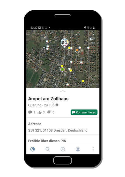
This is where the Data4City project for safe school and leisure routes comes in. For this purpose, the mobile and map-based app solution Pin City directly involves those affected on site: parents, school children and all other interested parties capture precise information on individually configurable topics such as crossing points, path conditions, lighting and visibility conditions or traffic density. Additional information, such as whether children are travelling by bicycle or walking, can also be collected. Surveys in defined areas, such as bus stops, can also be carried out through the app. All functions can be configured for the individual application on site.
The intuitive operation and low-threshold playful elements of the Pin City app uncover previously unknown ‘grey spots’ on school and leisure routes with the knowledge of those involved. Descriptions and photos can be noted, which the other participants can comment on and review. All information is available with a high level of detail and accuracy, eliminating the need for cost-intensive digitization processes.
Possibility of facilitation and processing of on-site information in the Data4City Cockpit
The Data4City Cockpit supports authorities and other groups involved in the overall process and management of the data. This way, the collected on-site information is automatically processed and merged with existing official data. Via a facilitation function, the web application enables direct communication with the app users. Simultaneously, targeted messages and notifications can be sent to the participants of current projects via the PinCity message channel. Each message can accessed in the cockpit with its associated photos, descriptions and comments, so that the information provided can be used directly, for example, in the creation of school route plans or for internal administrative purposes. Furthermore, the collected information can be retrieved as a raw data set with geo reference in the usual office- and json-format. The configuration of a data interface is possible based on individual customer requirements.

Creation of safer school and leisure routes with digital information
In cooperation with parents, children and other interest groups, Data4City for safer school and leisure routes offers a solution for precise collection of digital on-site information.
This gives the authorities involved a digital database for an efficient creation of school route plans and targeted planned actions. In addition, the solution makes a valuable contribution to increasing the acceptance of measures taken within civil society and to strengthening local civic engagement to improve the safety of school and leisure routes.


